


The insane number of dams and aqueducts in California
My friend Rowan is in town again I’ve been preparing to do another big round of editing work on our water oligarchy doc this coming week (yeah, we’re still working on it) and was looking through some research materials, when I came across a great map we were able to snag a while back that shows the scale of California industrial water system.
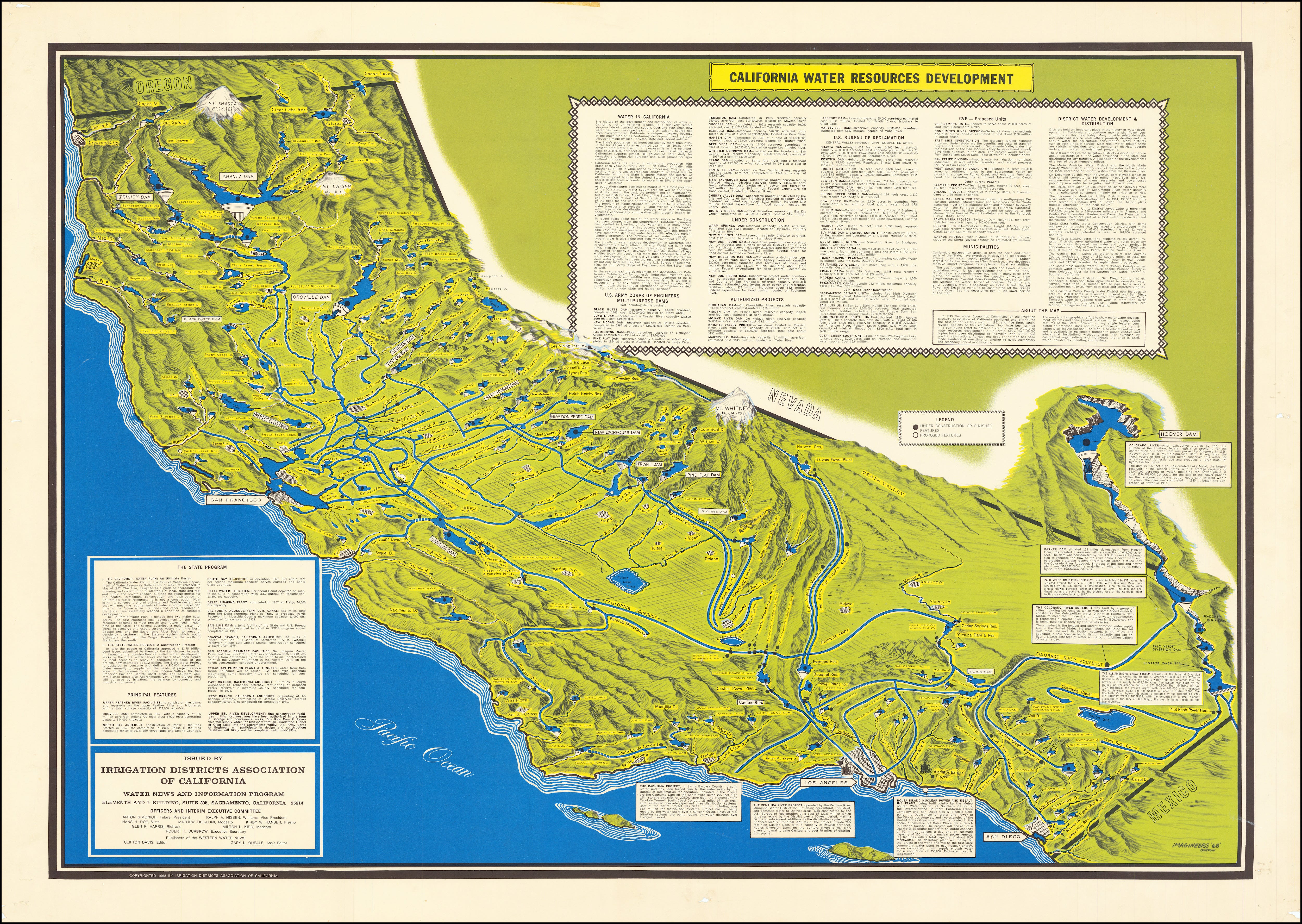
I don’t think people get just how dam crazy California was during the 20th century. To say there is a dam on just about every major and minor river and creek in California is no exaggeration. There are something like 1,500 dams here. Some were built and get managed by local governments, other were funded by the state and the feds. And of course dams don’t do much on their own. They need aqueducts. So California also has thousands of miles of concrete rivers to move water south and east — from the mountains to the cities and, mostly, to the farmer-oligarchs that own the Central Valley.
But these are all numbers…sometimes you need a diagram to get the scale. And this map does the trick. It’s from 1968 and, even though it omits most of the smaller dams, it gives you sense of how big it is and most of its major components. And remember: a big chunk of this infrastructure is dedicated to funneling a precious (and shrinking) public resource, annihilating wildlife, and terraforming the land — all to to enrich a tiny group of wealthy famers who grow pistachios, a luxury snack food that almost no one here eats and that is mostly exported.
We just released Pistachio Wars. Watch it today!
This water system is publicly funded but is ultimately outside of democratic control. No one here cares or thinks about how water is distributed or for what purposes it is used, so the people who benefit from this public system get to run it for their own profit and nothing else.
Anyway, if everything goes according to plan, we’ll have this doc finished this year. Pray for us!
—Yasha Levine
Want to know more?
Some mike Davis-esque research going on here. He might be a cool person to interview for this.
Also I’m not sure if you saw but apparently there was a “Chinatown” style leaking of 26m $ worth of water from a reservoir in Fresno recently.
Of course you're going to have a lot of dams in California-- it's southern half is basically a desert that some moron decided to turn into a lush green playground. Not exactly hard to imagine that when you couple massive over population in the Orange County area with massive agricultural issues that were accelerated with the Dust Bowl in the 1930's you end up with state with water issues.